In ancient times, there was no single toponym for the modern continent of Africa. The lands to the west of Egypt in ancient times were called Libya’, from the tribe of the Libyans. The ancient Greeks learned this toponym from the Egyptians as early as the time of Homer. In the III century BC. c. the first mentions of the toponym Africa appear, which then denoted the lands around the Phoenician city of Carthage (the modern territory of northern Tunisia). Phoenician afer meant “the lands of Carthage”. The ancient Roman historian Terentius has an explanation of the toponym as “Land of Africans” (lat. Africa terra), which he derives from the name of the local Berber tribe of Africans, Africans, and Ifrigs. That is, one of the branches of the Saharan population, which has preserved its own ethnonym until modern times – Targa (Tuareg). Traditionally, the name of the people is derived from the Phoenician word afar – “dust”, modern researchers derive it from the Berber ifri – “cave”, that is, the Ifrigi are cave dwellers, who were also mentioned by Herodotus. The same word is found in the name of the North African tribe “Banu Ifran” (Ifranids), who lived in the territory of modern Algeria and Tripolitania, centered around the modern city of Yafran; also in the name of the Moroccan city of Ifran. In ancient times, the term “Asia” was used to denote Asia Minor and the lands east of it. Originally, Egypt and the Levant had an indeterminate status between Africa and Asia, although as part of the Persian Empire they were sometimes included under the more generalized term “Asia”. The dividing line between these two continents was first marked by the geographer Claudius Ptolemy (85-165), drawing the prime meridian through Alexandria and making the Isthmus of Suez and the Red Sea the boundary between Asia and Africa. The ancient Greeks tried to derive the toponym from their own goddess Aphrodite, or the Semitic Astarte (Ishtar).
After the conquest of Carthage by the Romans in 146 BC. e. as a result of the Punic Wars, thanks to the influence of the Greeks of Southern Italy, this toponym was transferred to a new Roman province (lat. Africa Proconsularis). In Latin, the toponym was formed by combining the ethnonym of the local population with the suffix -ica (compare Caesar’s Celt-ica from the name of the local Celt tribes, Celtae, used by him in Notes on the Gallic War). The 1st-century Jewish historian Josephus claimed that the toponym came from the name of Ether, Abraham’s grandson by Keturah (Genesis 25:4), whose descendants settled Libya.
The historian of the 7th century Isidore of Seville in his “Etymologies” (volume XIV, section 5.2) mentions the interpretation of the word Latin. aprica as “sunny”. In the Middle Ages, after the Arab conquest of the African Exarchate (lat. Exarchatus Africae) of Byzantium, the province of the caliphate was formed – Ifrikiya (Arab. إفريقية), which retained the Latin root in its name. The medieval historian Leo the African (1495-1554) extended the name “Africa” to the entire Mediterranean coast of the continent. He proposed the hypothesis of the origin of the name from Dav.-Gr.α φρίκη – “without cold/horror”. But since the sound of ph on f in the Greek language dates back to about the 10th century, it is unlikely that this is the true origin of the toponym.
Oecumen of the time of Herodotus
Allegory of Africa statue, Ferreria Palace, Malta
Map of the world in “Etymologies”, edition of 1472
European map of Africa, 1570
Self-taught Egyptologist and poet Gerald Massey in 1881 put forward a version of the origin of the word from the Egyptian expression af-rui-ka — “to turn one’s face to the opening of Ka.” The Ka is the energy double of each person, and the “Ka hole” means the womb or place of birth. Africa thus meant “homeland” for the Egyptians. According to the Soviet paleontologist and writer Ivan Efremov, the word “Africa” was learned from ancient Egyptian by the Greeks as αφρος – “foam country”. That was due to the collision of several types of currents that form foamy eddies on the Mediterranean coast.
Michel Fruit in 1976 connected the toponym with Latin. africus – “south wind”, which was of Umbrian origin and originally meant “rain wind”. Robert R. Stiglitz from Rutgers University in 1984 proposed to connect the toponym Afir-ik-a with the legendary biblical land of Ophir, which was famous for gold. The Arab writer Ibn Khallikan hypothesizes the origin of the name of the continent from a Khimyarite king named Afrikin ibn Qays ibn Saifi, who was also called “Afrikus, son of Abraham” and who conquered Ifrikiya.
Read more: Geography of Africa
Geographical location
Africa is the second largest continent after Eurasia, the largest of the continents of the Southern Hemisphere. The area of the continent is 29.2 million km² (with islands — 30.3 million km²). Africa is the only continent located in all four hemispheres of the Earth: Northern, Southern, Eastern and Western (most of it in the Northern and almost all of it in the Eastern). In general, in equatorial-tropical latitudes, it is almost symmetrical with respect to the equator. The length of Africa from north to south is 8,000 km (from Cape Ras Engela 37°21′ N to the southernmost point — Cape Golkovo (Agulyas) 34°51′15″ S), from west to east in in the northern part — 7,500 km (from Cape Almadi 17°33′22″ E to Cape Ras Gafun 17°33′22″ E), in the south — 3,100 km. In the north, Africa is washed by the Mediterranean Sea, in the west directly by the Atlantic Ocean, in the east by the Red Sea and directly by the Indian Ocean. It is connected to Asia by the Isthmus of Suez, 130 km wide, cut through by the Suez Canal. It is separated from the Asian Arabian Peninsula by the deep Bab-el-Mandeb strait (depth at least 182 m, total width 26.5 km). It is separated from Europe by the relatively narrow Strait of Gibraltar (14 km).
Satellite photo of Africa
Comparison of the size of Africa with the territory of some countries
Strait of Gibraltar
Bab-el-Mandeb strait
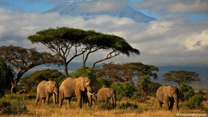
The coasts of Africa are poorly divided, mostly high, difficult to access, the length of the coastline is 26 thousand km. The largest and only large peninsula of the continent is Somalia in the west, which is called the “Horn of Africa”. The bays are slightly indented and wide open to the ocean, the largest of which are: Guinea in the central part of the west coast, Sidra in the north, Aden in the east. There are few convenient bays. There are no large archipelagos around the shores of the continent, the largest island of Madagascar (587 thousand km²) lies east of the southern coast and is separated by the longest strait in the world — Mozambique (1,670 km), which separated from the mainland as a result of a tectonic fault tens of millions of years ago. The following islands and archipelagos also belong to Africa: Madeira, Canary Islands, Cape Verde, Sao Tome, Principe, Ascension, Saint Helena, Tristan da Cunha, Socotra, Pemba, Zanzibar, Mafia, Comoros, Amirantes, Seychelles, Mascarene Islands and other. In the Red Sea and the Indian Ocean, numerous coral reefs form near the coasts, which complicate navigation and prevent sea vessels from approaching the coast.
Geology
In the geological structure, the African lithospheric plate corresponds to the African continent, which moves north towards the Eurasian one with an angular velocity of 0.292° ± 0.007° per million years. A belt of tectonic faults passes through the rift zone in East Africa, which started the process of breaking off the Somali and Arabian plates from the African plate 60 million years ago. The Red Sea and most of the East African lakes were formed at the site of these faults. The Afar Trough is a zone of active separation of these plates.
Most of the continent is occupied by the Precambrian African platform, consisting of crystalline slates, gneisses, granites, basalts and other igneous and metamorphic rocks. In the northern part of the continent (Sahara plate), the foundation of the platform lies at a considerable depth, it is covered by a thick multi-kilometer cover of Paleozoic-Cenozoic sediments (including marine ones), which were formed as a result of weathering, wind and surface waters over millions of years of tectonic vertical movements. They reach their greatest power in tectonic basins. In the southern part of Africa (South African shield), the Precambrian basement is generally slightly raised, sedimentary deposits occur only in separate basins and are continental in nature. In the northwest, the Atlas Mountains were formed during the Hercynian-Alpine folding from the uplifted and folded sea floor during the collision with the Eurasian plate; in the south – the Hercynian Cape Mountains. Paleozoic rocks (sandstones, shale, dolomitized limestones) lying on a crystalline foundation are weakly dislocated, broken in places by intrusions of granites, granodiorites, and gabbros.
In the Mesozoic, 180 million years ago, the African-Arabian massif broke away from the ancient continent of Gondwana. Mesozoic rocks are represented by marls, sandstones, and limestones, which in some places are strongly enriched with underground water (especially in the Sahara). In the Cenozoic 60 million years ago, intensive uplifts took place in the east of the continent, which led to the formation of mountainous relief and fault zones of the Great African Rift with deep grabens, often filled with lake waters (Tanganyika, Nyasa), which stretched from the mouth of the Zambezi to the Gulf of Suez for 4,000 km. km Along the fault lines there is an active volcanic-seismic belt with numerous active and extinct volcanoes (Kilimanjaro, Kenya), frequent earthquakes. Until recent geological time (late Cretaceous-Oligocene), the African-Arabian platform also included the Arabian Peninsula and the island of Madagascar, separated today from the main part of the platform by rift zones in the northeast and the Mozambique Channel in the east. Cenozoic rocks are represented by Eocene limestones, lagoonal and continental deposits.
Movement of the African lithospheric plate
African Rift Zone
Craters of the Cameroon volcano
Dallol volcano hydrothermal vents, Eritrea
The Big Hole kimberlite pipe, South Africa
The continent is rich (its bowels contain 30% of the world’s explored deposits) in a variety of minerals: hard coal, uranium, diamonds, oil, natural gas, iron ores, manganese, chromium, cobalt, polymetals, bauxite, gold, platinum, significant phosphorite reserves (North Africa), asbestos, graphite (gneiss strata of Madagascar), diamonds (South Africa) and others. The placement of minerals is related to the tectonic structure of the continent. Thus, ores are confined to the igneous and metamorphic rocks of the foundation of the platform, and non-ores or ores of sedimentary origin to its cover of sedimentary rocks.
Relief
The relief of Africa is dominated by plains, plateaus and plateaus lying at heights of 200-500 m above sea level (39% of the area) and 500-1000 m (28.1%). This is explained by the general rise of the entire territory of Africa in the Cenozoic era. Lowlands stretch in narrow strips along the coast and occupy about 10% of the mainland area, mountain massifs account for more than 23% of the territory. In terms of average height above sea level (750 m), Africa is inferior only to Antarctica and Eurasia. The advantage of the flat terrain on the mainland is due to its platform structure. The depressions and protrusions of the African platform correspond to large depressions – Kalahari, Congo, Chad and others. Lava plateaus and cones are widespread in the Ethiopian highlands and in East Africa, they crown the peaks of Ahaggar and Tibesti, there are in Sudan (Mount Marra), Cameroon (Volcano Cameroon, Adamawa Mountains), they cover the Dragon Mountains in Lesotho.
Low Africa. The north-western part of Africa is occupied by the plains and plateaus of the Sahara and Sudan with the predominant heights of 200-1000 m. In this part of the continent with a deep foundation and a wide development of the sedimentary cover with an intensive development of peneplenization, heights of less than 1000 m prevail. Only in some places are the Atlas mountain ranges raised mountains (Mount Toubkal, 4165 m), the Ahaggar Highlands (Mount Takhat, 3003 m) and Tibesti (Mount Emi-Kusi, 3415 m), the Northern Guinea Plateau (Mount Bintimani, 1948 m), the Azande Plateau (Mount Nagaya, 1388 m), the Darfur plateau (Mount Marra, 3088 m), the Etbay ridge (Mount Oda, 2259 m) stretches along the Red Sea, and others. The surface is very heterogeneous – highlands alternate with lowlands and plateaus. Deep basins below sea level are concentrated mainly in the northeastern part of the continent: the basin of Lake Assal (-150 m) in the Afar Basin, the Kattar basin (-133 m).
Relief map of Africa
Kilimanjaro is the highest peak of the continent
The basin of Lake Assal is the lowest point of the continent
Ethiopian highlands
Dragon Mountains
High Africa. The southern and southeastern parts of the continent are higher, with characteristic heights of more than 1,000 m. The eastern edge of Africa is most elevated and fragmented within the activated section of the platform, where the complex system of East African faults extends. In the elevated regions of High Africa, the largest area is occupied by basement plains and basement boulder mountains, framing the depressions of East Africa. Plateaus and boulder mountains predominate — the Southern Guinea Mountains, the Ethiopian Highlands (Mount Ras Dashan, 4,620 m) steeply breaks off in the east and descends in ledges in the west, the Lunda-Katanga Plateau, the East African Plateau (Mount Ruwenzori, 5109 m), medium-altitude Cape Mountains (Mount Sevewispurtpik, 2325 m) and Dragon Mountains (Mount Tabana-Ntlenyana, 3482 m). The highest peaks of the continent are cones of stratovolcanoes (Kilimanjaro, Meru). The Dragon and flat-topped Cape Mountains drop off to the Mozambican lowland in a large escarpment. The interior regions of South Africa are occupied by the high Kalahari plains, bordered from the west by the Namaqualand, Damaraland, and Kaoko plateaus, from the east by the Dragon Mountains, and from the south by the Cape Mountains, which descend to the narrow coastal plain through the Great Escarpment.